


Col de L'Escuchiere départ Mousteiret + 582

claude nier
User
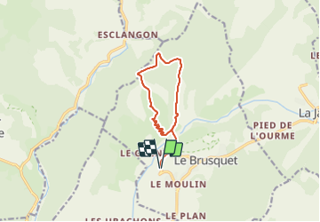

Length
11 km

Max alt
1260 m

Uphill gradient
582 m
Km-Effort
18.7 km

Min alt
730 m

Downhill gradient
582 m
Boucle
Yes
Creation date :
2023-11-21 16:36:26.199
Updated on :
2023-11-21 16:36:27.893
4h15
Difficulty : Difficult

FREE GPS app for hiking
 SityTrail
IGN / Geographical institutes
SityTrail Plus
The world is yours!
About
Trail Walking of 11 km to be discovered at Provence-Alpes-Côte d'Azur, Alpes-de-Haute-Provence, Le Brusquet. This trail is proposed by claude nier.
Description
Belle rando..
à faire
Positioning
Country:
France
Region :
Provence-Alpes-Côte d'Azur
Department/Province :
Alpes-de-Haute-Provence
Municipality :
Le Brusquet
Location:
Unknown
Start:(Dec)
Start:(UTM)
283320 ; 4893070 (32T) N.
Comments